
One of the many decisions that go into siting wind turbines is their potential impact on birds and bats – new technology makes it possible to hone in on an individual’s flight patterns.
Through the Department of Interior’s Smart From the Start Program, large swaths of offshore waters have been identified as appropriate for wind farms.
But where are the best (and worst) places to put individual turbines within those areas?
The Bureau of Ocean Energy Management (BOEM) has awarded the US Fish & Wildlife Service $292,000 to track the flight patterns of marine birds of high concern from Massachusetts’ Nantucket Sound through the mid-Atlantic region.
American oystercatchers and Common Terns will be tagged with transmitters during the spring nesting season and monitored over the next 12-18 months during their wintering and migration periods. Other recent studies have looked at other bird species.
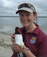
The photo below shows Pamela Loring, Principal Investigator, University of Massachusetts, holding an American Oystercatcher. They are large shorebirds with long orange bills used to shuck shells of clams, mussels, and oysters:
"The study, which our migratory bird program helped design, will test the ability of cutting edge technology, called NanoTags, to track offshore movements of the birds," says Caleb Spiegel, a biologist with the US Fish & Wildlife Service.
"We have some real holes in our knowledge of how marine birds use the offshore environment, and this is a problem when we’re thinking about putting commercial-scale wind turbines in the Atlantic," he says. "We need to know where these bird concentrations are and try and avoid them."
These studies complement those that use aerial and boat surveys to zero-in on where the greatest population densities are of various bird species are throughout the year.
NanoTags send information around the clock to a network of tracking towers – they are able to detect birds within about 8 kilometers of the towers.
The NanoTags weigh 1-2.5 grams, much lighter than tags that can send information via satellite.
Researchers are always looking for smaller, lighter technology to track birds. Solar-powered satellite tags extend battery life substantially but have so far been limited in their use because of weight, but a 5 gram tag is being manufactured and tested.
This project is a collaboration between University of Massachusetts Integrative Graduate Education and Research Traineeship Program in Offshore Energy and the US Fish and Wildlife Service that is funded by the Bureau of Ocean Energy Management.
Another recent technology used to site offshore wind farms is UK-based Aveillant’s 3D Holographic Radar. It allows air traffic controllers to track aircraft in areas where there are wind turbines.
Migration is a complete mystery, and cannot be “tracked” in any meaningful manner…..it changes. It is known that to track migration in the Great Lakes, will take years, and possibly be obsolete by the time it is completed. Wind power doesn’t work, on or offshore. It provides meaningless amounts of power, and does irreparable harm to the environment. I hope you will consider the additional noise from drilling, and cables with electro magnetic fields in the oceans as well. Many species of ocean dwellers are suffering incredibly…beaching from the din. Please do the real studies: wind doesn’t work. 225,000 turbines world wide producing less than 1/2 of one percent. Carbon fibres that can’t be recycled in the blades, and now accruing massive industrial waste yards. Let’s mention the highly toxic rare earth elements in the magnets. We are going to regret this big con game. Very much.