When it comes to deforestation, it’s increasingly a game a hide and seek.
Corporations intent on denuding our planet continue finding ways to avoid laws or bribe officials and the rest of the world is intent on exposing and stopping them.
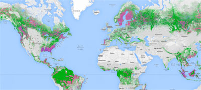
Global Forest Watch is a breakthrough, allowing us to see where deforestation is occurring through satellite images. That’s about to take another step forward with the ability to predict deforestation before it happens, enabling authorities to prevent it altogether.

Using Global Forest Watch images, a company called Orbital Insight will create algorithms that detect patterns which indicate deforestation is likely, such as the presence of logging trucks, road-building in undisturbed areas and thinned canopies.
"We currently know a lot about forest clearing that has happened in the past, but soon we will have the power to look ahead and identify the forest areas at greatest risk," says Aaron Steele, Chief Technology Officer for World Resources Institute, which created Forest Watch.
Or, Just Use a Cellphone
In Africa’s Congo Basin, anyone can report illegal logging to authorities simply by using a cellphone, even if they aren’t within reach of mobile networks, because the information is sent via satellite modem transmitter.
"Our ‘real time’ technology is potentially a game-changer, as it helps empower forest people even in the remotest areas, and could transform the way that forests are monitored and governed," says Simon Counsell, Executive Director of Rainforest Foundation UK.
"We are inviting governments of rainforest countries to work with us on a full-scale test of how community-based monitoring can be linked to formal enforcement mechanisms," says Counsell. The system can also be used to detect wildlife poaching and human rights abuses.
US-based Rainforest Connection is also piloting the use of cell phones to pick up noise associated with poaching and logging, such as gunshots and chainsaws. The system automatically alerts local authorities or conservation managers.
Rainforest Foundation UK initiated the project as part of its attempt to help threatened indigenous people map their land rights:
 Loading...